NEWS
Assessing the risk of contamination in an open-air dump using drones and geographic information systems
An innovative methodology to assess the risks of contamination in open dumps
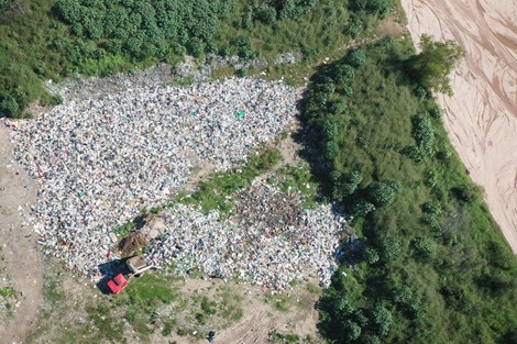
Municipal solid waste (MSW) management is a global challenge that requires innovative solutions. This study proposes a new methodology to analyze open dumpsites in Tucumán, Argentina, using drones and geospatial analysis tools.
Using drone flights and DroneDeploy software, researchers captured high-resolution images that they then processed in QGIS to assess the risk of contamination at the sub-basin level. The combination of satellite images, field surveys, and digital terrain models allowed for a detailed view of the status of a specific dumpsite.
A key aspect of the methodology is the use of artificial intelligence to delineate the areas occupied by waste from orthomosaics.
The study highlights that the use of drones is a fast and low-cost alternative to map and monitor open dumps. However, it recommends validating the data with field studies and considering groundwater in future research. With these advances, the proposed methodology not only improves the understanding of the environmental impacts of landfills, but can also be replicated in other regions to optimize waste management and reduce its negative effects on the environment and society.
https://doi.org/10.1177/0734242X251314180